Road Network Characteristics
The Mpumalanga Department of Public Works, Roads and Transport (MDPWRT) is responsible for the establishment and maintenance of the provincial road infrastructure. The responsibility for the total road network in Mpumalanga is shared among the three spheres of Government, as follows:
- National roads fall under the responsibility of SANRAL
- The MDPWRT is responsible for the establishment and maintenance of the provincial road infrastructure
- Local municipal roads and streets fall under the responsibility of district and local municipalities.
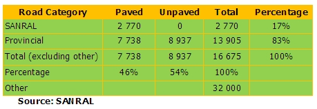
- There is an estimated 2 770 km (carriageway length) of national roads in Mpumalanga Province, which include the N2, N3, N4, N11, N12 and N17, as well as some R-routes such as the R23, R33, R35, R37, R38 and R40.
- There is an estimated network of 7 647 km of paved road (carriageway length) in the province, which represents about 46 percent of the total national and provincial road network.
The extent of national and provincial roads in Mpumalanga Province is summarised in the following table.
Notes:
- These road lengths are carriageway lengths. The total centreline length is 2 300 km, which include 679 km of toll road.
- The 2007 provincial road database was used as a basis. However, this database was adjusted to account for roads that have been transferred from MDORT to SANRAL, e.g. the R33, R35, R38 and R40.
- This network includes about 21 000km of gravel access roads (not classified as provincial roads, and some of them are private roads or forestry roads) as well as an estimated network of 11 000 km of municipal and urban roads and streets.
About 4 150 km of the paved road links (or 54% of the total paved road network) has an average annual daily traffic (AADT) of less than 2 000 vehicles / day. About 570 km of road links (or 7% of the paved road network) has an AADT of more than 10 000 vehicles / day. Most of the road sections with the high traffic levels are located on the N4, the R40, R544 and the N12 (NATMAP, 2008).
Road Network Challenges
In terms of the province's road network, the main challenges related to the fact that (MDORT, 2007a):
- Only 14% of the national road network in the province is in a good or very good condition
- The overall condition of the provincial paved road network has declined substantially during the last two decades, resulting in a significant backlog of rehabilitation and maintenance requirements and consequent high budget requirements
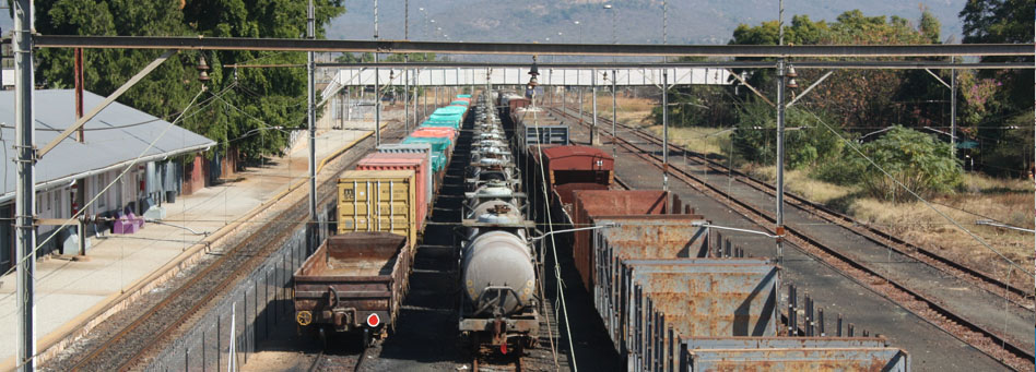
- A significant portion of freight transport has moved from rail to road transport (e.g. mining and forestry related freight transport). This has put tremendous pressure on the road network leading to early pavement failure.
- At an average age of 30 years, most paved roads in Mpumalanga are at the end of their design life - which means that maintenance issues should be high up on the agenda - in fact, the greater part of the budget should be reserved for maintenance.
For a complete report on the conditionn of the national roads in Mpumalanga, click here.
Maputo Development Corridor
Background
The Maputo Development Corridor, comprising road, rail, border posts, port and terminal facilities, runs through the most highly industrialised and productive regions of Southern Africa, the most notable of which is Gauteng, which produces 40% of South Africa's GDP. The MDC enables Gauteng's (and its landlocked neighbours) importers and exporters shorter, greater, more cost-effective and faster access to its nearest deep water ports. Besides industrial and mining goods, agricultural products especially fruits move through the corridor. The bulk of the MDC runs through Mpumalanga which boasts of 76% of South Africa's coal mining output and 50% of national coal reserves, some of which is exported via the Matola Coal Terminal in Matola Port, Maputo. MDC also links with production centres (industrial/chemical complex) in Gert Sibande, steel producing areas of Nkangala and agricultural/tourism (including the Kruger National Park) areas of Ehlanzeni district municipalities. Crossing the Lebombo / Resanno Garcia border into Mozambique's Maputo Province, the Corridor connects the South African northern hinterland with Mozambique's capital, Maputo and its two deep water ports of Maputo and Matola. The MDC is part of a greater transport and development axis linking the deep sea port of Walvis Bay in Namibia on the Atlantic seaboard and Maputo on the Indian Ocean through Trans-Kalahari Development Corridor.
The Maputo Corridor Logistics Initiative (MCLI), which performs secretariat duties for the MDC, is a non-profit organisation consisting of infrastructure investors, service providers and stakeholders from Mozambique, South Africa and Swaziland. MCLI facilitates interaction between all stakeholders across national borders to focus development endeavours in the corridor by seeking to:
- Remove barriers along the MDC
- Inform the market of developments on the MDC, and
- Market the strategic benefits and opportunities as a result of usage thereby making the MDC the first choice for the region's importers and exporters alike.
Project Aims
- Rehabilitate the primary infrastructure network along the Maputo Corridor - including road and rail links between South Africa and Maputo, the border post between the two neighbours and the Maputo Port
- Maximise investment in the corridor area and added opportunities that infrastructure rehabilitation would create
- Maximise social development, employment opportunities and increase participation of historically disadvantaged communities
- Ensure sustainability by developing policies, strategies and frameworks that ensure holistic, participatory and environmentally sustainable approach to development in the corridor
Objectives
- Realise the inherent resources potential along and adjacent to the corridor (through feeder corridors)
- Facilitate the rehabilitation and upgrading of traditional transport and trade links between Mozambique and South Africa's inland areas
- Maximise investment in the corridor area and in added opportunities created by the rehabilitation project
- Ensure that the development impact of this investment was maximised especially among disadvantaged communities
- Ensure sustainability by developing policies, strategies and frameworks, which encompassed a holistic, participatory approach to development
Achievements
- US$5b invested in the MDC
- 24-hour Joint One Stop Border post - currently in progress
- N4 completed
Increased road safety 5% per annum traffic growth rate 10% per annum freight vehicles
- Harbour concessions in place and successfully managed by private sector - increased infrastructure investment
- Increased traffic - port and terminals (3Mt in 1996 vs. 6.6Mt 2006)
- Increased shipping services
- Comparative freight and travel times and cost
- Cross border people flow (365K in 1993 vs. 3,081K in 2006)
- Cross border road freight growth (29Kt in 1997 vs. 1.2Mt in 2006)
- Cross border rail freight growth (800Kt in 1995 vs.2.5Mt in 2006)
- Increase in tourism and trade (South Africa and Mozambique)
- Further investment in port and terminals - US$273m
- Petro pipeline
- Maputo Corridor Water Project
- Maputo Metallurgical Complex
Projects
The MDC initiative has to date helped facilitate over $5 billion in private sector investments into regional infrastructure development, industrial development and natural resources exploitation and beneficiation.
Key infrastructure investments included the following:
- The N4 Maputo Toll Road - a PPP awarded in 1997 to the Trans African Concessions Consortium (TRAC) for a period of 30-years, and estimated at R1.5bn at the time
- The management agreement with Liverpool's Merseyside Docks and Harbour Company to upgrade and operate the Maputo Port for an estimated US$65m initial investment
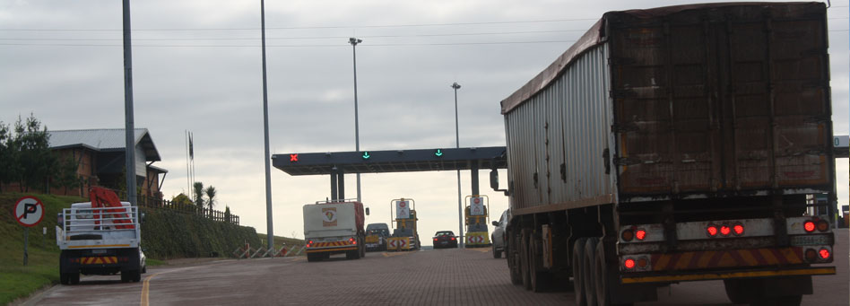
- Improvements to the Lebombo Border Post carried out for an estimated R20 million
- The construction of two high voltage electricity lines from Duvha (SA, near Johannesburg) to Maputo through a SA-Mozambique electricity utilitie's JV (Motraco)
- The development of the Pande/Temane gas field in Mozambique and the construction of a pipeline to SA (US$1.4bn) by Sasol (SA) and ENH (Mozambique)
Some of the other investments include:
- Investments into the Mozal Aluminium Smelter at Maputo by South Africa's Billiton (now BHP Billiton) in a joint venture with South Africa's IDC (about US$1.5bn for Phase I and a further US$1bn in Phase II). Phase III of this project is now under consideration
- The Beluluane Industrial Park, a 600 hectare industrial free zone development adjacent to the Mozal plant, is attracting a mix of foreign, regional and local investors into heavy industry, manufacturing and hi-tech businesses
- The Corridor Sands Project at Chibuto some 180 km north of Maputo, holds the world's largest mineral sands deposit of high quality smelter feed ilmenite (titanium mineral). This investment for the construction of a titanium smelter, will be located next to Mozal and will create up to 1 600 jobs
- Numerous smaller investments in the tourism (hotels), retail, manufacturing and services sectors
- A US$2bn iron and steel complex in Matola, based on South African ore and Mozambican gas, is currently being assessed.
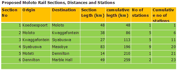
The Moloto Development Corridor runs along the R573 (Moloto road) - from Siyabuswa, through KwaMhlanga to Tshwane. The corridor currently carries about 40 000 passengers per day, mostly during the morning peak, commuting between Dr JS Moroka and Thembisile local municipalities and Gauteng. A regional passenger rail service along this corridor has been proposed to reduce travel time and accidents with a view to improving the quality of life of affected communities. A feasibility study has confirmed the viability of constructing rail infrastructure between Gauteng and Siyabuswa (the primary section). The table below shows the rail line lengths and the number of stations as per currently preferred alignment.
The corridor which caters largely for passenger traffic and relatively light freight (especially in terms of frequency and loads - as petroleum, furniture, soft drink and building materials deliveries) was conceived as an integrated transport system that would improve public transport by providing a multi-modal integrated system consisting of rail (main line) and road based (feeder) services with a view to:
- Lessening travel time and reducing the number of accidents on the corridor
- Providing affordable and safe travel solutions for both government and passengers by means of a cost effective system
- Improving regional accessibility and linkages
- Securing transport system capacity to absorb future increases in commuter numbers
- Broadening the economic base of the province by means of dedicated local economic development programs with the corridor serving as a spine and catalyst for development
- Positively impacting on the social lives of commuters by means of spin-offs of the improved public transport system and economic benefits that flow from the corridor initiative.
The Moloto road is in a relatively good condition and a weighbridge is in place which discourages overloading. Fatalities on the corridor are mainly related to passenger movements. While Witbank is the industrial centre and has been rapidly growing, most people on the corridor are employed in Tshwane, mainly in government as there is not much economic (industrial) activity taking place save the new Reconstruction and Development Plan (RDP) house-type settlements and a shopping complex at Siyabuswa. 'Cashbuild' - the building materials chain store is located in a number of centres on the Moloto corridor signifying the importance of light (small) freight in regenerating local economies. Other freight generating activities would include bakeries and general dealers.
Tshweleni Corridor, which serves six mines links Middelburg in Steve Tshwete local municipality to eMalahleni (Witbank) in Emalahleni local authority, is under severe pressure from intensive truck traffic (R555). This has been worsened by the fact that a strategy for the development of the corridor which was started sometime ago was never completed. The need for a robust framework with the buy-in of all stakeholders to guide spatial development in the corridor cannot be over-emphasized. The framework should be underpinned by an impact study, particularly on adjacent roads such as the R20 provincial road.
In terms of corridors in Nkangala District Municipality, roads that require immediate investment because of the increased truck traffic which often damages the roads would include, R104, R105 and R545 which are in a bad condition and R555 which has sections in poor condition. 'Red running': Traffic tends to escape the N4 tolls run by TRAC into the R555 administered by SANRAL with the result that R555 has and continues to deteriorate substantially. The need for a strategy to curb 'red running' which is a product of extensive consultation with stakeholders including the district authority, the private sector and communities is certainly clear.
Abbreviations and Acronyms:
- GDP: Gross Domestic Product
- IDC: Industrial Development Corporation
- JV: Joint Venture
- MCLI: Maputo Corridor Logistics Initiative
- MDC: Maputo Development Corridor
- NDC: Nkangala District Municipality
- PPP: Public/private/partnerships
- RDP: Reconstruction and Development Plan
- SA: South Africa
- SANRAL: South African National Roads Agency Limited
- TRAC: Trans African Concessions Consortium
- TKDC:Trans-Kalahari Development Corridor
Introduction
The condition of roads in Mpumalanga is captured in its Road Management System (RMS). The visual evaluation of the roads in the province was undertaken employing best practice guidelines TMH9 for paved roads and TMH12 for unpaved roads. It is of interest to note that there are 17 links where the AADT exceeds 10,000 vehicles per day on single carriageway paved roads which is the volume at which planning for some form of dual road or widening would normally be considered.
Condition of National Roads in Mpumalanga Province
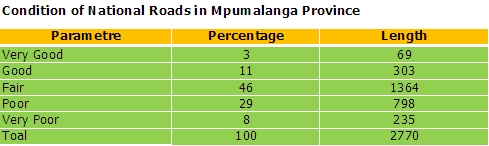
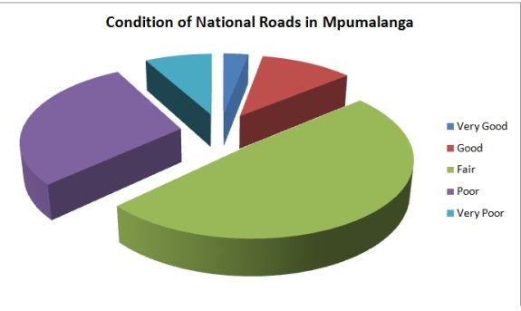
The roads in a very poor condition are generally located south of Ermelo, mostly around the N11 between Ermelo and Volksrust. The provincial road network in the coal haulage area (generally the area between Witbank, Middelburg, Secunda, Ermelo and Amersfoort) has deteriorated significantly in recent years, due to the increased road-based transport of coal between mines and power stations.
Paved Road Conditions
Overall Visual Condition: The condition of the paved road network can be assessed by viewing the year on year distribution of the Visual Condition Index (VCI). Visual inspections take into consideration and present an overall view of the road condition including its surface condition, cracking, patching, potholes and riding quality. The longest sections with poor and very poor road condition occur in the Gert Sibande and Nkangala regions. These roads are mostly located around the coal fields between Witbank and Volksrust.
Functional condition: In order to assess user perceptions of the road conditions the functional condition of the road as represented by the riding quality is more appropriate. All regions have a similar proportion of roads with a poor riding quality and that only the Gert Sibande and Nkangala regions have sections of roads with a very poor riding quality.
Steady and in some cases, rapid deterioration has occurred over the years as the roads have become older. Because the expectation is that large sections of road network will tend to deteriorate rapidly, particularly over the rainy season, the need to ensure that surfacings are well sealed to prevent moisture ingress into the pavement which accelerates the occurrence of distress cannot be over-emphasized.Road identification: Road identification information in the province is generally poor and it is difficult to identify locations on the road network. Kilometre costs are replaced as part of rehabilitation projects that are undertaken along the road network, but there is no strategy to address the lack of kilometre posts alongside roads that are not due for rehabilitation.
Roadside drainage: Drainage is a major problem on many roads and requires improvement. Drainage improvement has the potential to create a number of useful jobs as part of the EPWP.
Edge drop: Many roads in the province have a substantial edge drop between the top of the surfacing material and the adjacent road shoulder. This results in an unsafe situation and requires the reinstatement of the shoulder.
Patching: While much of the road patching is of a high standard and should necessarily extend the life of the roads, particularly where the standard of the patches is similar to that of the rest of the pavement, many of the temporary patches being placed with cold mix are weak and quickly show signs of deformation under heavy traffic.
Heavy vehicles: The number of heavy vehicles in the coalfields in Gert Sibande and Nkangala districts is substantial. Clearly, it is important to have stringent monitoring strategies in place to ensure that they comply with legal load requirements and to reduce overloading.
Gravel Road Conditions
The gravel road network is extensive, particularly in the Gert Sibande region. Many of these roads are also in a poor condition and very poor gravel quality together with a poor to very poor riding quality requiring urgent re-gravelling or re-shaping.
Concluding Remarks
Approximately, a quarter of the paved road network is in a poor to very poor condition and requires substantial maintenance and/or rehabilitation. Some sections of the paved road network where the surfacing is old require resealing to prevent moisture ingress and arrest further deterioration. Significant sections of the network have a very poor riding quality and represent a hazard to traffic. These roads require urgent attention in the form of rehabilitation and strengthening. The amounts required for road maintenance and improvements are substantial.
The gravel road network is showing signs of distress and the current backlog is huge. Furthermore, some roads where the traffic volumes exceed 600 per day need to be considered for upgrading. This is in addition to the upgrading programme required to facilitate access to communities that are not served by a paved road at present. There are several types of road distress, which can be addressed cost-effectively using labour-based methods in line with the NPWP. These include:
- Drainage improvements
- Shoulder reinstatement and elimination of edge drop, and
- Repair of surface cracking and ageing.
- There are other types of distress, which require more mechanized repairs that include:
- In-situ remixing and stabilizing of pavement layers in localized areas, and
- Resealing.
Recommendations
Because of the extent of the needs relative to budget expectations the Department needs to develop strategies that will deliver the most optimal conditions within the available budgets. This will not only entail optimising overall planning at the network level but also entail maximizing the effectiveness of project level designs and ensuring efficiency in terms of the delivery of the works. The road functional classification must be employed to generate a strategy of differentiating maintenance standards developed to ensure that a higher priority and standards are applied to the higher order roads while less important roads can have slightly lower maintenance standards.
Source: NATMAP (2008)
Mpumalanga Road Infrastructure Improvement Program
Mdpwrt Summary Maintenance Budget 2009-2010
Mdpwrt Summary Budget 2010-2011
The National Transport Master Plan (NATMAP, 2008) process identified in Mpumalanga five projects as priorities, namely:
- Develop a regional passenger rail system: Moloto Corridor
- Upgrade provincial coal haulage roads
- Develop a regional passenger rail system: R40/R538 Corridor
- Develop a regional passenger rail system: N4 Corridor, and
- Doubling of the Overvaal tunnel.
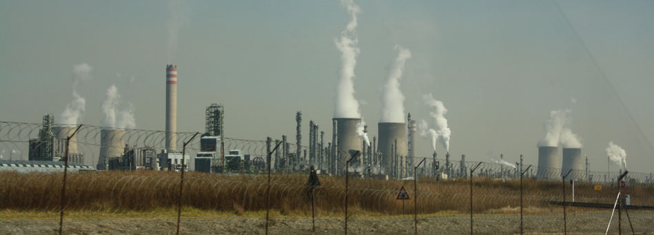
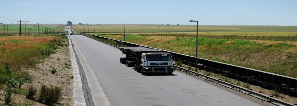
Coal Haulage Roads
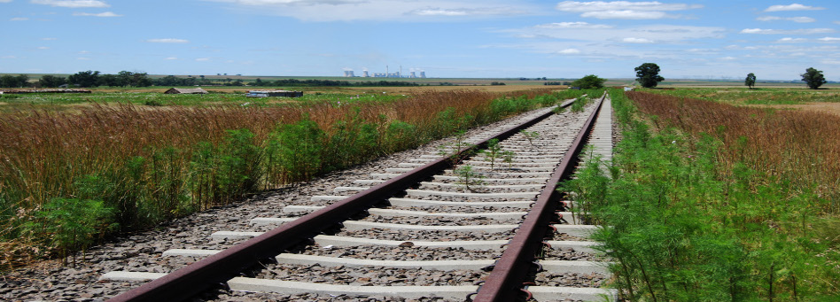
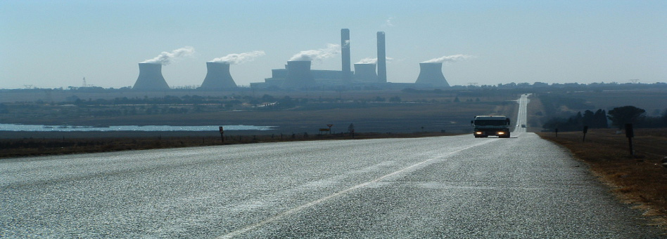
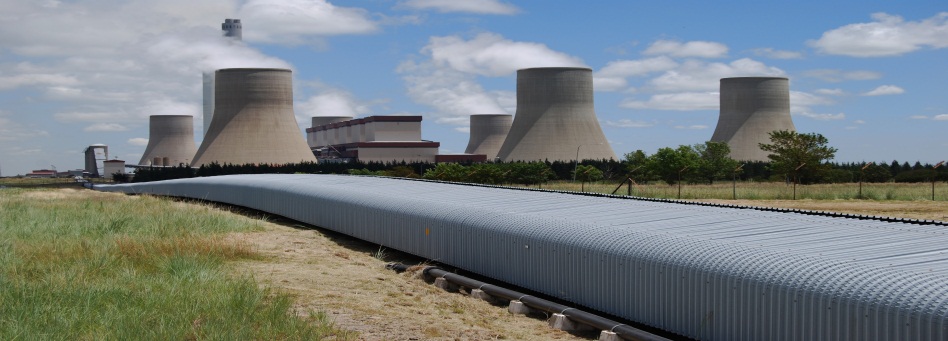
Mpumalanga is endowed with significant mineral resources, one of which is coal. It also houses coal-based industries such as Sasol and Eskom power stations. Thermal coal is also exported through Richards Bay. A combination of factors such as the phenomenal growth in demand for electricity as a result of accelerating growth and development, and rail service bottlenecks, coal haulage by road has grown considerably on Mpumalanga's provincial roads. The rapid increase in coal hauling by road (especially to the Majuba and Tutuka power stations) has resulted in significant road condition deterioration to the point where the surface on some roads has broken up completely. This, in turn, has forced Eskom to use alternative longer routes to reach destinations thereby placing an unnecessary premium on the cost of coal. A consequent effect is that the alternative routes are suffering the same degradation as the preferred routes.
Given that most of the affected network only has two major structural layers, their structural integrity is severely compromised because of the high frequency of heavy coal trucks especially in the Gert Sibande and Nkangala districts.The Mpumalanga Department of Public Works, Roads and Transport (MDPWRT) have limited funds for frequent rehabilitation and maintenance needs related to the coal haulage network. In addition, it is considered imprudent for the department to commit funding on the coal haulage network to the detriment of the rest of the provincial road network.
Regional Passenger Rail System: R40/R538 Corridor
The R40 and R538 form part of three important development corridors in the province, namely:
- Phalaborwa SDI (between Phalaborwa and Mbombela)
- Mbombela-White River corridor, and
- Karino-KMIA-Plaston corridor.
These corridors support freight and passenger movement related to industrial, commercial, mining and agricultural activities. Large population centroids occur in the Bushbuckridge area, as well as the rural areas just to the east of the R40 and R538 resulting in significant volumes of passengers travelling along this corridor. It also forms part of the emerging corridor between Zimbabwe and Mbombela, via Louis Trichardt, Giyani and Bushbuckridge.
NATMAP identified the R40/R538 corridor between Mbombela and Acornhoek as one of Mpumalanga's Strategic Public Transport Network (SPTN) corridors, due to the relatively high passenger numbers currently travelling along the R40/R538, and due to its future public transport potential. NATMAP estimated the public transport potential of this corridor in excess of 20 000 passengers per day (by 2015). Furthermore, a capacity analysis of the R40 road showed that, by 2050, the full length of this road between Acornhoek and Barberton will experience poor levels of service, and will require the addition of one lane per direction.
NATMAP proposes the implementation of a rapid transit system be in the corridor, as follows:
- Conduct a feasibility for the construction and implementation of a regional passenger rail system along this corridor
- If a regional passenger rail system is not feasible, investigate the option of implementing rapid transit, in the form of light rail transit (LRT) or bus rapid transit (BRT), along the full length of this corridor
- If a rapid transit system is not feasible, additional
capacity (in the form of 1 lane per direction) will have to be provided on the
R40, as follows:
- Period 2010 to 2015: Hazyview to Bushbuckridge
- Period 2015 to 2030: Bushbuckridge to Acornhoek; Mbombela to Barberton
- Period 2030 to 2050: White River to Hazyview; White River to Mbombela
Develop a Regional Passenger Rail System: N4 Corridor
The N4 Maputo Corridor between Gauteng and Maputo has been identified as a national and regional development corridor. The corridor supports freight and passenger movements between urban areas and economic centres of Tshwane and Johannesburg, eMalahleni, Middelburg, Mbombela and Maputo. It also connects these urban centres with Port Maputo, supporting the country's export market. This corridor has also been identified as one of Mpumalanga's Strategic Public Transport Network (SPTN) corridors, due to the relatively high number of passenger numbers currently travelling along specific sections of the N4, as well as latent and future public transport potential (especially between Pretoria and Kaapmuiden). NATMAP estimates the public transport potential of this corridor in excess of 15 000 passengers per day (by 2030). Furthermore, a capacity analysis of the N4 road along this corridor showed that, by 2050, most of the road between Pretoria and Kaapmuiden will experience poor levels of service, and will require the addition of 1 lane per direction.
NATMAP proposes the implementation of a rapid transit system be implemented in this corridor, as follows:
- Conduct a feasibility for the construction and implementation of a regional passenger rail system along this corridor
- If a regional passenger rail system is not feasible,
investigate the option of implementing rapid transit, in the form of light
rail transit (LRT) or bus rapid transit (BRT), along specific sections of the
corridor, specifically the following:
- Between eMalahleni and Middelburg, and
- Between Mbombela and Kaapmuiden
- If a rapid transit system is not feasible, additional capacity (in the form of 1 lane per direction) will have to be provided on the N4, as follows: - Period 2015 to 2030: R575 intersection to R104 intersection in the Middelburg area; Mbombela to Malalane; R104 intersection to Belfast
- Period 2030 to 2050: N4 southern leg between eNtokozweni and Elandshoek (just before Mbombela); N4 northern leg between R36 intersection and Elandshoek
Overvaal Tunnel Capacity Doubling
Approximately 50 percent of all rail freight in South Africa passes through the single track Overvaal tunnel. A significant portion of South Africa's international primary commodity exports pass through the tunnel. Its importance cannot be over-emphasized. The tunnel portal area is 24.85 km south of Ermelo. The single line section is 5.265 km long from the last signal at Overvaal on the north end, to the track circuit at the south end protecting the points. Given that the longest trains are 2 505 m long, locomotives have to travel a distance of 7.770 km before the rear of the train clears the protecting track circuit at the south end of the tunnel - before the next northbound train can only commence passage into the tunnel. Approaching trains are often bunched and sometimes opposing movements coincide and there are periods with no trains at all. In this first come first served control system, throughput is somewhat less than what is theoretically possible with 42 trains a day in each direction being the maximum capacity - with attendant delays from time to time. Efficiency is thus determined to a degree by the train scheduling, train flow and the train length. This means that the medium-term expansion envisaged from 34 slots a day to 44 slots a day will push its current capacity to over 100 percent causing frequent extensive delays. NATMAP proposes commencing the construction of the second tunnel when the traffic on the first tunnel reaches 50 slots per day in each direction. That way the second bore will be ready before the first bore reaches 90 percent utilisation.
NATMAP Short-term priority projects: 2010-2015
Notes:
- While coal haulage roads are considered a priority, there has been no funding commitment towards these. Other innovative ways of funding such roads need to be found.
- Mbombela Northern Bypass will reduce congestion and pollution in the city centre as a result of truck traffic - which will now be diverted to the bypass.
- Additional capacity on the trunk roads assists in reducing congestion, accidents, etc.
- Providing for public transport in the form of HOVs and particularly transit rail has the effect of reducing congestion through modal shift, reducing green house gases, by allowing traffic including trucks to move much more efficiently.
- Constructing pipelines has the same effect - removing from the traffic stream a significant number of trucks
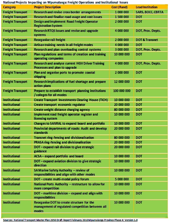
National Projects Impacting on Mpumalanga: Freight Operations and Institutional Issues
Copyright © 2010 Mpumalanga Province Freight Transport Data Bank [ - ]
All rights reserved.
This website conforms to W3C Standard [ - ]