O.R. Tambo
Introduction
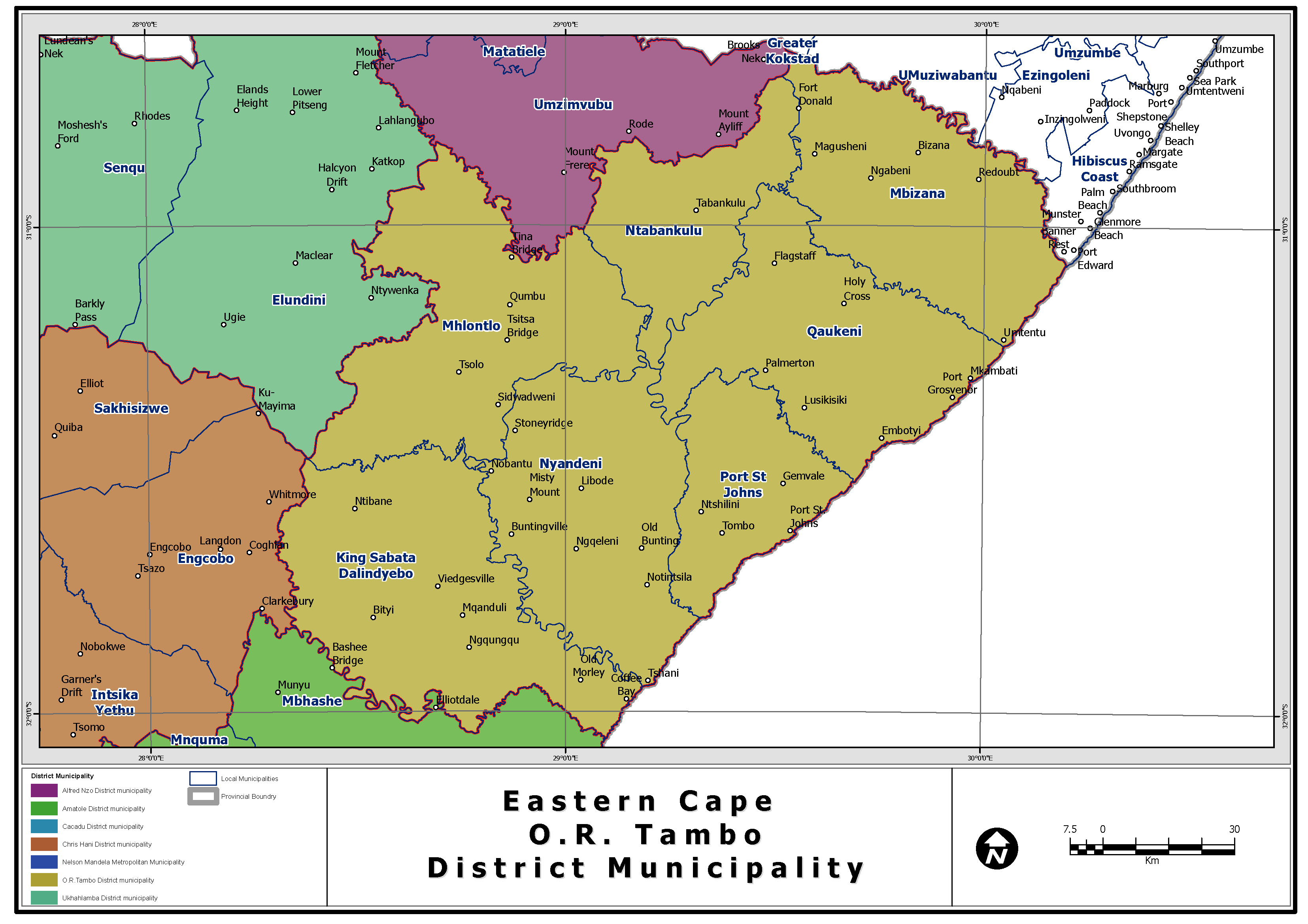
The O.R. Tambo District is located to the east of the Eastern Cape Province, on the Indian Ocean coastline of South Africa. It is bordered by the Alfred Nzo District to the north, the Ukhahlamba District to the northwest, the Chris Hani District to the west and the Amathole District to the southwest. From the east to the west the District measures 170 143 km, north to south 121 725 km and it measures 12857 km² in extent. It is located approximately 140 km from Queenstown. OR Tambo is one of the 7 districts of Eastern Cape province of South Africa. The seat of OR Tambo is Umtata. The majority of its 1 676 463 people speak Xhosa (2001 Census). The district is within Wild Coast Region. OR Tambo is surrounded by:
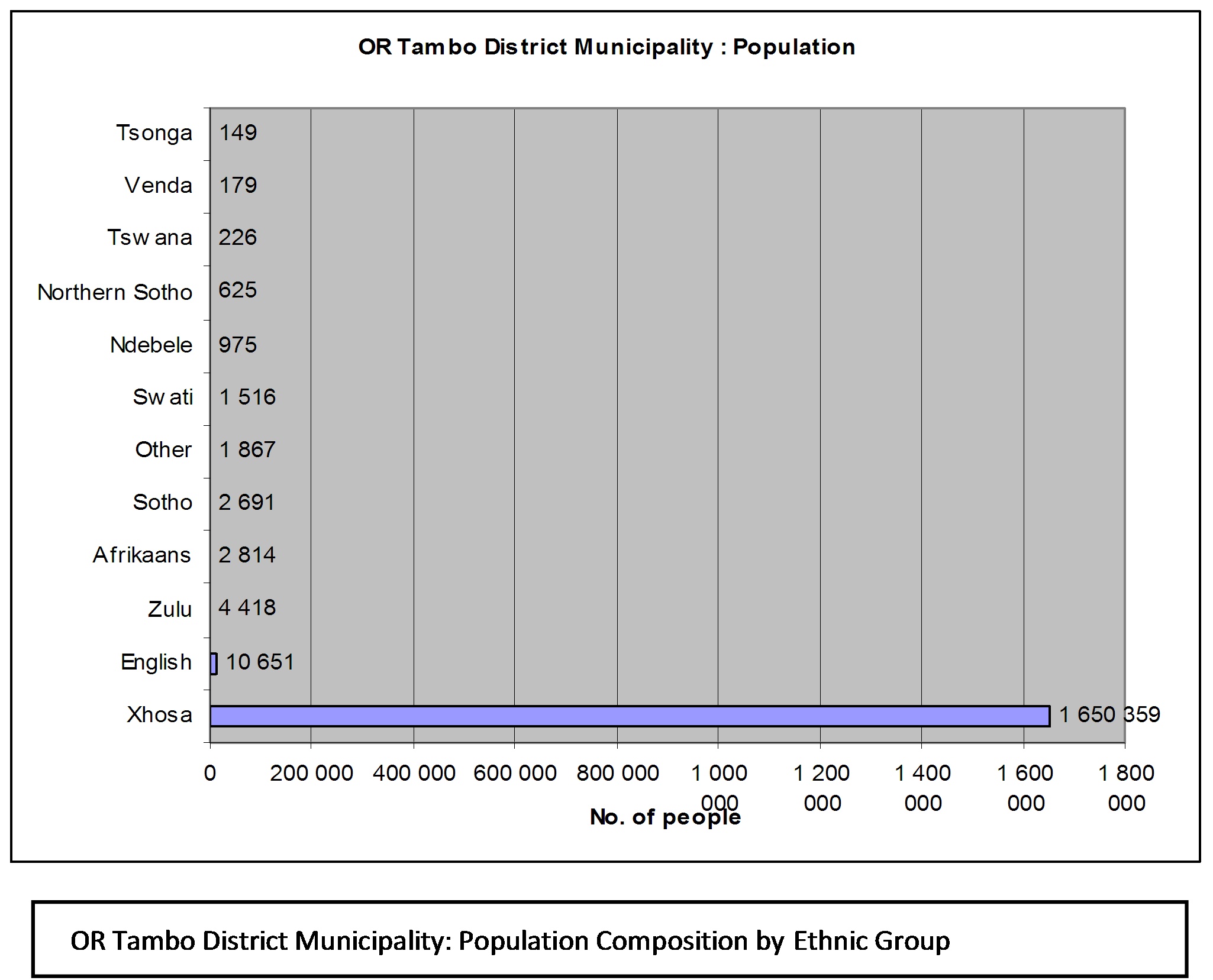
The district contains the following local municipalities: King Sabata Dalindyebo, Nyandeni, Qaukeni, Mbizana, Mhlontlo, Port St. Johns, Ntabankulu. King Sabata Dalindyebo which constitutes 24.77% of the total population in the District has the highest population figures. Mhlonto with about 11.73% of the total population in the district represents the middle sized municipality. The small sized municipality in terms of population count is represented by Ntabankulu with a 8.14% portion of the total population in the district. Freight transport desire lines and movement are influenced by population density and corridors between the major districts municipalities’ record higher traffic and face by extension bigger challenges. This also relates to tourist traffic. Understanding the district municipality population dynamics is important in informing freight transport investors, operators and division makers in terms of appropriate policy interventions and response taking into account the gender dimensions, the ethnic groups. Such sensitivity is essential in transport freight empowerment and indigenisation initiatives such as the BBBEE (refer to OR Tambo ethic group composition table). The King Sabata Dalindyebo municipal area has the highest population density of 142 people per square kilometre, followed by Port St. Johns with 118 people per square kilometre. Mhlontlo has the lowest population density with 79 people per square kilometre. This high density of people per square kilometre will result in a lower level of services, which means more people having to share services. It is important to note that the population densities are relatively high in ratio to the road infrastructure provision in this area. Furthermore, the District has a low functionally urbanized population (6.7%) with approximately 93.3% of the District’s population residing in rural areas.
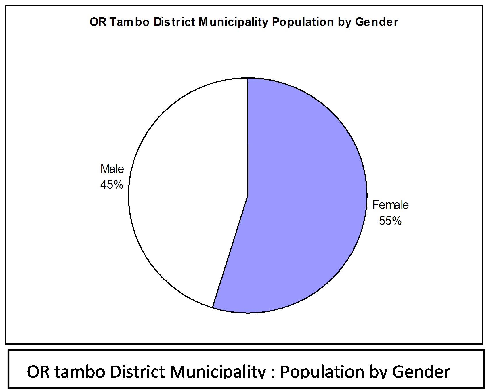
Approximately 47.6% of the District’s population falls within the 15 - 65 age category. This group can be seen as the economically active sector of the population. The fact that 46.5% of the population falls within the under 15 age group, suggests continuing population growth in the District with a need for educational facilities and a focus on education and skills training. The dependency ratio is 1:5, which means that each employed person sustains an average of five members of their family. In many instances families are dependent on elderly people who receive pensions. The overall male – female ratio is approximately 45.1% male to 54.9% female (refer to pie chart diagram). This may be ascribed to migrant and commuter labour which has resulted in many households having a woman as the head of the household and the chief breadwinner living away from the home. This will ultimately impact on the type of development that will occur within this District.
The government sector (53%) is the largest sector contributing to the Gross Geographic Product (GGP) of the local economy, followed by trade and then the finance sector, each with 10%, respectively. The economic development of the region has the following constraints which impact negatively on the current economic development of the District:
There are a number of conservation areas within the O.R. Tambo District Municipal area. Provincial nature reserves include Silaka Nature Reserve near Port St Johns, Hluleka Nature Reserve near Presley Bay, Luchaba Nature Reserve next to Umtata Dam and Mkambati Nature Reserve on the northern Pondoland Coast. There are also a large number of indigenous forest reserves all along the coast. Some of the larger ones on the Pondoland Coast (moving north from Port St Johns) are Mount Thesiger, Mount Sullivan, Ntlopeni, Lotana, Mbotyi, Egosa and Ntsubane. There is also a proclaimed marine reserve adjacent to the Mkambati Nature Reserve.
Development nodes are identified in the Wild Coast SDI to serve as investment anchors; particularly in the Mkambati-Mtentu area where there is a proclaimed nature reserve and forest reserve, incised by the Msikaba and Mtentu Rivers. The area is also rich in cultural heritage and Tourism Clusters have been initiated using the SMME and community based organisations. Port St. Johns is a resort area with well-known beaches, one of which is situated in the Silaka Nature Reserve. At Coffee Bay and Hole in the Wall, there are unique coastal resorts, rich in natural and geological features; whilst the Dwesa/Cwebe Nature Reserves, located in the southern portion of the SDI area and divided by the Mbashe River, offers enormous resort and eco- tourism potential.
Agriculture
Although the District is predominantly rural with large tracts of arable land, the agricultural sector of the economy is poorly developed. Agriculture in the region is largely subsistence in nature. The Langeni Forest and Magwa Tea are the major contributors to the primary sector of the economy. The Mondi Forests will also soon be reaching its maturity state and thus be a major contributor to the economy. The secondary sector is relatively weak with little manufacturing and value-adding activity taking place. The trend in agriculture in the District is the reduction in the area under cultivation and the increase in residential land. Very little of the demarcated arable land is cultivated and much of this land has been left to grass. In contrast, there has been an increase in the homestead area, which is under cultivation; this being a result of the proliferation of large “rural” stands. The issue of land tenure and absence of family heads and economically active people also put constraints on agricultural development.
The rivers and coastline offer substantial potential in the form of various marine resources including fish and marine produce such as shellfish. There are substantial regions, which are under forestry - both indigenous and commercial forests. These offer potential for future enterprises in timber, manufacturing and export.
Settlement Patterns
The O.R. Tambo District encompasses diversity in physical landscape, land use and access to economic opportunities. Mthatha is the regional economic centre to the District, which is located on the central watershed. The location of Mthatha, however, poses a spatial challenge to the District with regards to the distances one would have to travel to get to local nodes in the eastern portion of the District. The western region is orientated towards Mthatha and East London and the Eastern region being influenced by Kokstad and Kwa-Zulu-Natal. O.R. Tambo is a large district with considerable spatial disposal and many regions being inaccessible due to the poor roads and rugged countryside. The minor nodes supporting Mthatha are: Qumbu, Ntabankulu, Tsolo, Mbizana, Flagstaff, Lusikisiki, Libode, Ngqeleni and Mqanduli.
The settlement pattern in the District is characterized by homesteads dispersed along ridge crests on the uplands and sometimes in the valleys on flat land. Areas along the coastline are sparsely populated. People tend to prefer to locate their homes inland. Migration has contributed to the urban growth of Umtata and the main service centres of Bizana, Lusikisiki and Port St. Johns. The following pattern is found in the O.R Tambo District Municipality:
Road Network Infrastructure
List of Abbreviations
NMMM Nelson Mandela Metropolitan Municipality GDPR Gross Domestic Product Revenue GVA Gross Value Addition GDP Gross Domestic Product PGDP Provincial Growth and Development Strategy RSA Republic of South Africa GGP Gross Geographic Product Roads - Constructed Roads Since 2000
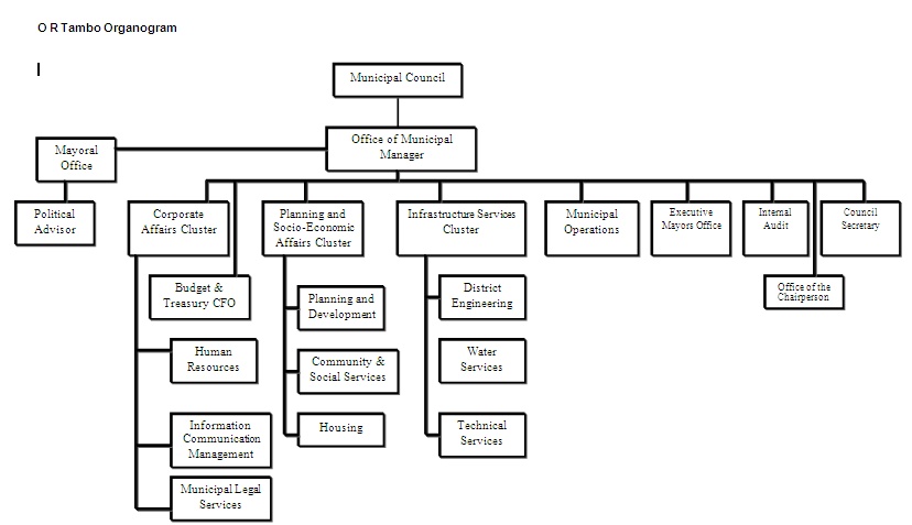
IDP, 2008 Organisation Structure
| ||||||||||||||||||||||||||||||||||||||||||||||||||||||||||||||||||||||||||||||||||||||||||||||||||||||||||||||||||||||||||||||||||||||||||||||||||||||||||||||||||||||||||||||||||||||||||||||||||||||||||||||||||||||||||||||