Chris Hani
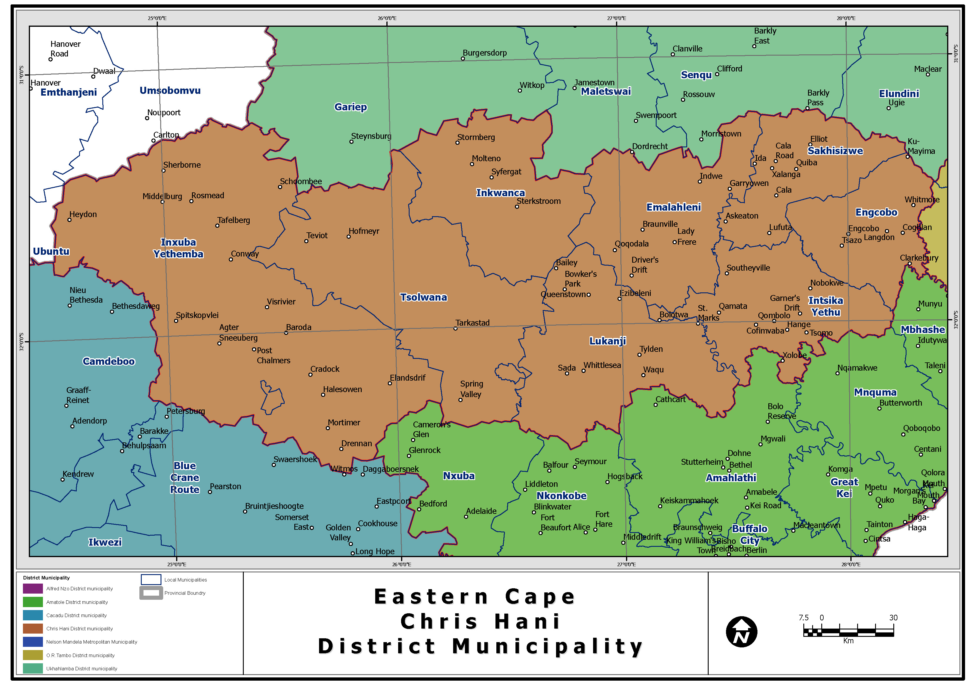
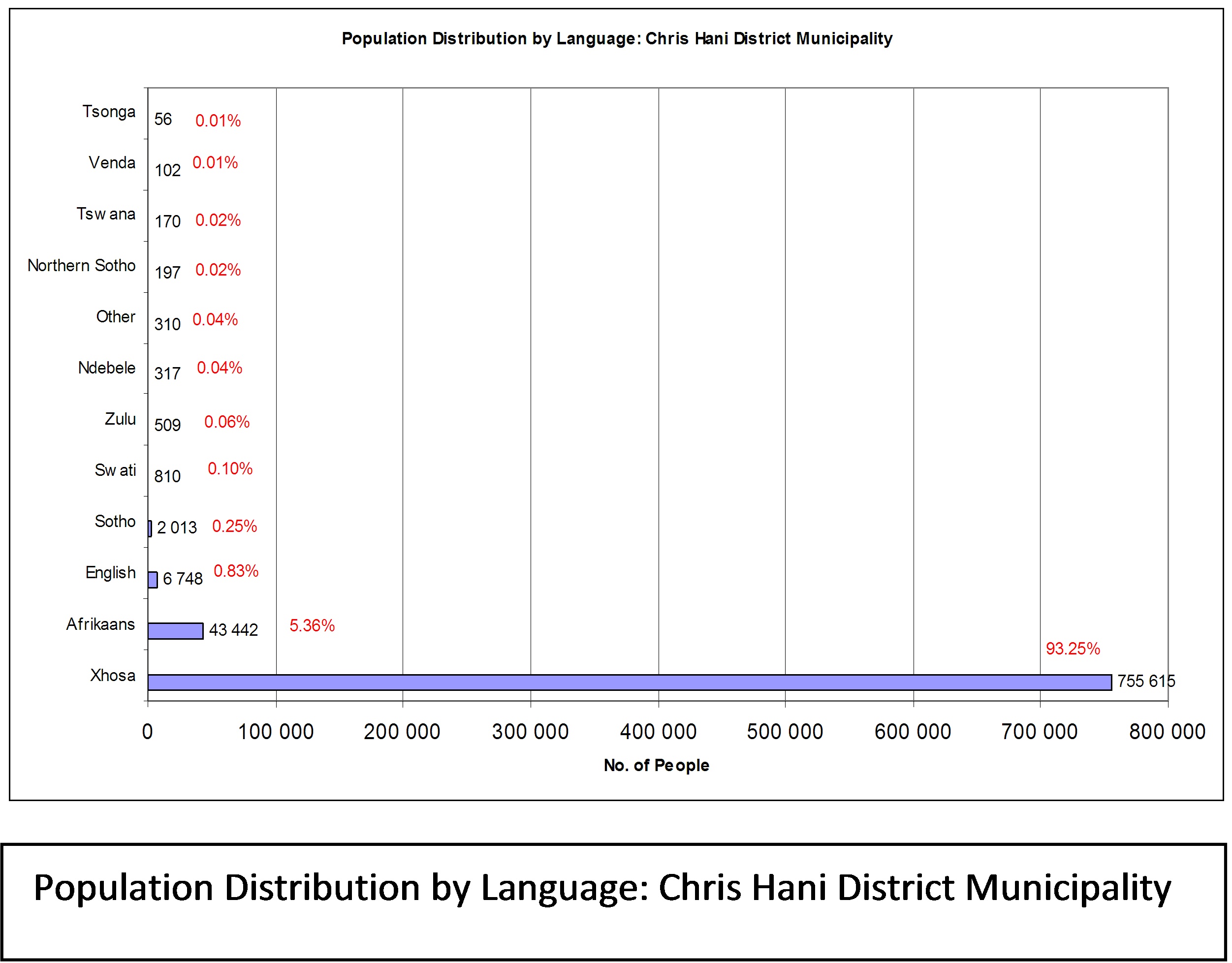
Introduction Chris Hani is one of the 7 districts of Eastern Cape province of South Africa. The Chris Hani District is comprised of three historically distinct areas, the result of which is seen in the spatial development of the District. The former Ciskei – made up of Hewu and Glen Grey magisterial districts – and the former Transkei – which includes primarily the districts of Ngcobo, Cala, Cofimvaba, Tsomo and Lady Frere magisterial districts – are characterised by significant underdevelopment and high levels of poverty. This is primarily due to historical policies, which saw such areas as providing migrant labour to the former Republic of South Africa (RSA), while ensuring that dependants remain settled within the homeland. The balance of the Chris Hani District Municipality area is made up of former RSA magisterial districts, which were administered under the Stormberg and Midlands Regional Services Councils. These areas are generally characterised by a higher level of services and a comparatively more affluent population. The majority of its 810 274 people speak Xhosa (2001 Census). Chris Hani is surrounded by:
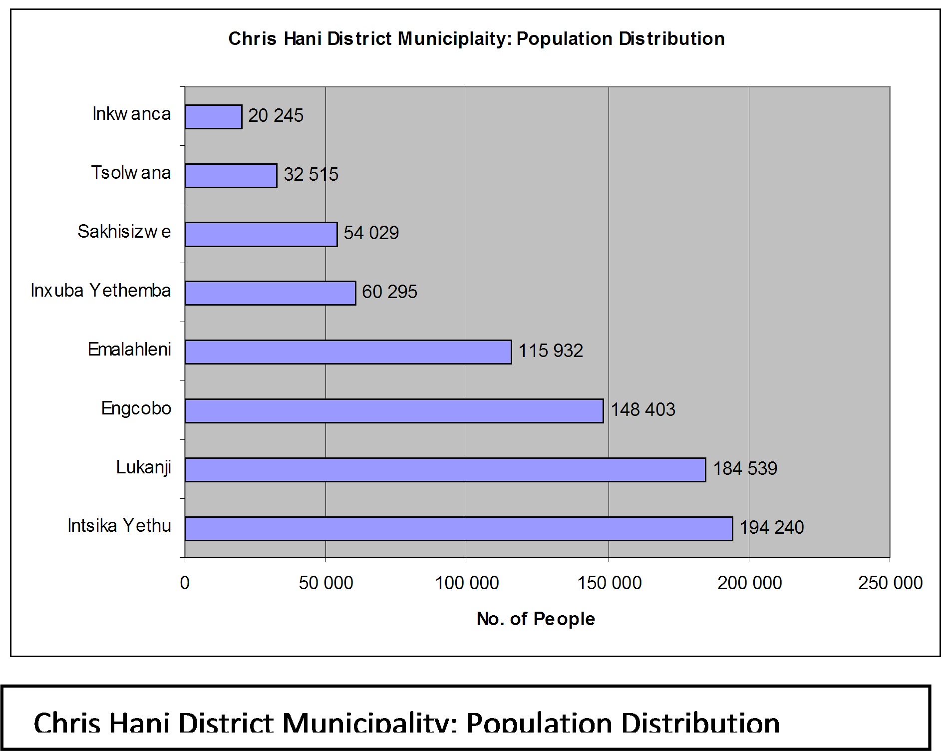
The district contains the following local municipalities: Intsika Yethu, Lukanji, Engcobo, Emalahleni, Inxuba Yethemba, Sakhisizwe, Tsolwana, Inkwanca. The population distribution can be divided into three tiers (refer to figure on population distribution to the right of this page) . The upper tier has a municipality each constituting between 18-24% of the total district population. This tier is made up of Intsika Yethu – 23.97%, Lukanji – 22.77% and Engcobo – 18.32%. The middle tier has each municipality constituting between 6-14%. In this tier, we find Emalahleni – 14.31%, Inxuba Yethemba – 7.44% and Sakhisizwe -6.67%. is made up of municipalities that each constitute approximately less than 4% of the total district population. Tsolwana – 4.01% and Inkwanca -2.50% make up this group. This population distribution has implications for freight distribution and logistics management. It also presents issues around small cargo and rural transport logistics for lowly populated areas such as Tsolwana and Inkwanca.
In conducting freight business in the municipality the need to take account of the local languages for communication is important. By the same token efforts for gender empowerment in freight and BBBEE are important given the gender and ethnic composition in the Chris Hani District Municipality.
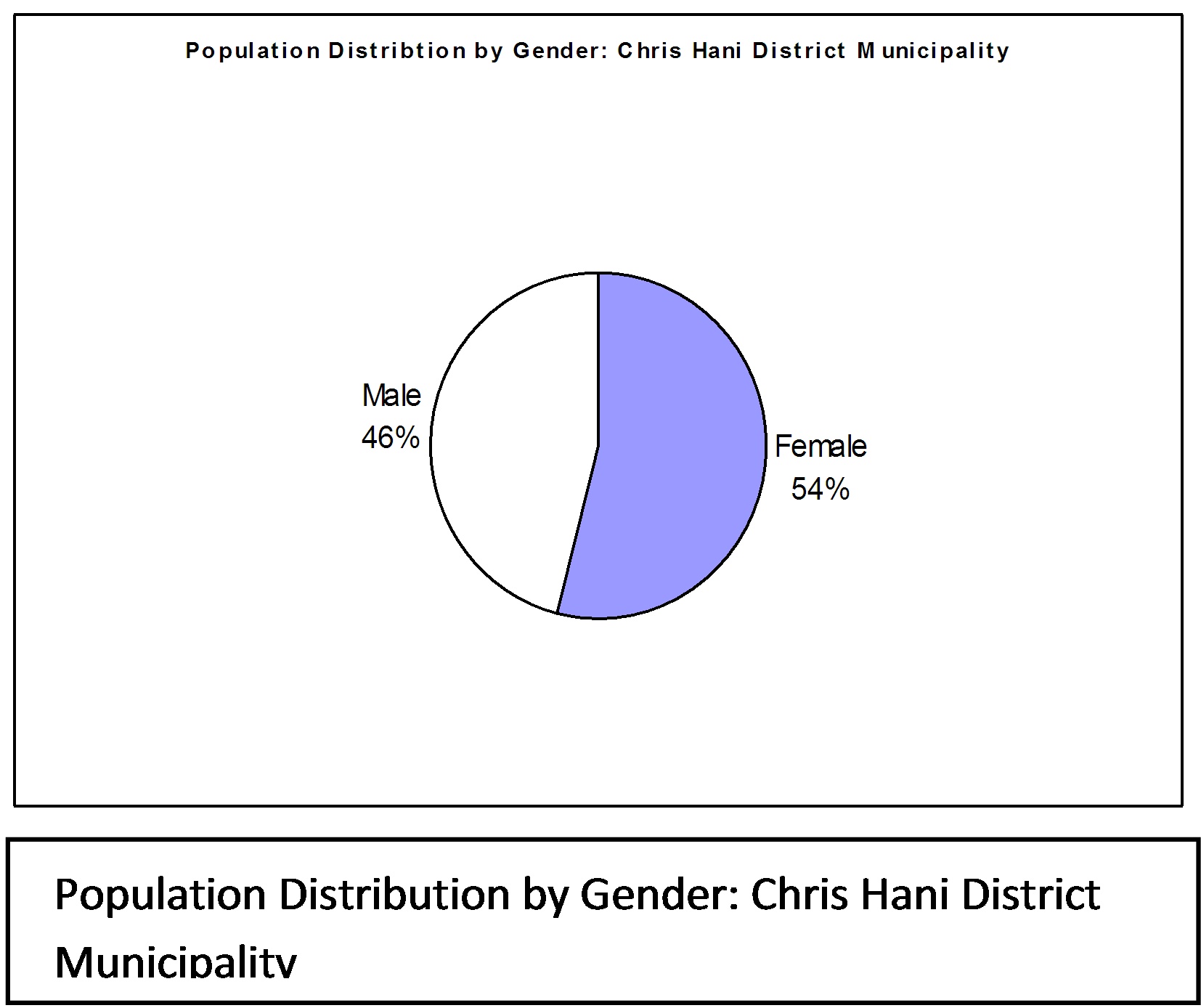
According to the 2001 Census Statistics, the total population of the Chris Hani District Municipality is some 810 214 people, which is 12 677 less than the 1996 population count of 822 891. Approximately 71% of the District’s population resides in rural areas, with the largest populations occurring in the Intsika Yethu, Lukhanji, Engcobo and Emalahleni municipalities. Just more than half of the District’s population is female (53.76%), which implies that the District, and the local municipalities under its jurisdiction, needs to ensure that women’s issues remain high on the political agenda (refer to pie chart diagram on this page). There are also far fewer men in the former homeland areas, which may largely be attributed to the fact that men are most often the migrant workers, leaving the women to care for children and the elderly.
The majority (20.2%) of Chris Hani residents are employed in the community/social/ personal services sector, followed by technicians and private households. This is in line with occupation trends throughout the Eastern Cape, whereby the majority of residents are employed by government services. The low number of people engaged in sectors outside the community/social/personal services sector indicates the limited diversity of these economies. However, almost a quarter of the income generated by residents in the Lukhanji and Ngcobo local municipalities is derived from primary economic activities (agriculture, hunting, etc). Lukhanji, being the commercial/service centre of the District, also has the most diversified economy. The agricultural potential of the District is significant. However, the high level of dependency on the community/social/personal services sector suggests that the agricultural economy within the District is largely underdeveloped. The challenge remains, therefore, to increase the agricultural and agro-processing components of the economy.
A number of conservation areas exist in the Chris Hani District Municipality. Only three of these conservation areas are under the direct control of the municipality, namely Koos Ras (Inkwanca), Lawrence de Lange (Lukanji) and Longhill (Lukanji). In addition, a National Park (Mountain Zebra National Park), a number of private nature reserves (i.e. Black Eagle and Blanco) and three natural heritage areas (i.e. Benghoil and Bushy Park, Carnarvon and Mhoge) are located, at least in part, within the Chris Hani District Municipality.
The formal protected area network is relatively extensive with the Mountain Zebra National Park and the Commando Drift, Ntabathemba, Tsolwana, Lawrence de Lange and Black Eagle Eastern Cape provincial reserves. The early selection of protected reserves in the Chris Hani District was based on ad hoc decisions to protect specific mammals rather than an objective criteria based on biodiversity mapping. Control of all indigenous forests in the Eastern Cape, including the District, was handed over to the Directorate of Nature Conservation of the Eastern Cape Province authorities in 1996, and management plans for all forests are still in preparation. Formally protected water sources include a number of large water catchments, including the dams:
Settlement Patterns
The Chris Hani District Municipality, as it is presently defined, represents an amalgamation of formerly separated administrative entities, namely, parts of the former “South African” Eastern Cape including the magisterial districts of Elliot, Molteno, Sterkstroom, Hofmeyer, Cradock, Tarkastad, Queenstown and Wodehouse; the former “Ciskeian” Districts of Hewu and Ntabathemba, and five magisterial districts of the former “Transkei”, namely Engcobo, Xalanga (Cala), Cofimvaba, Cacadu (Lady Frere) and Tsomo.
The settlement and land use patterns in these two former homeland areas are distinctively different. Specifically, settlement in the former Ciskei and Transkei is predominantly of the dispersed “traditional” rural village settlement type, where subsistence-farming practices (pastoral and dry land cultivation) are the dominant forms of land use activity apart from the residential function of these areas. In contrast, settlement and land use in the former RSA component of the District is largely characterised by nodal urban development (small service towns) and commercial farms.
Largely, the spatial pattern of the District is characterised by a “mismatch” of separate rural and urban areas, which are nevertheless functionally interrelated and dependent on a core area (Queenstown). At the District level analysis, it is possible to distinguish between primary and secondary urban nodes, minor urban areas and rural-residential settlements in the Chris Hani District Municipality:
Most of the population of Chris Hani District Municipality is rural and situated in the eastern part of the former Transkei. Most of the existing housing stock is therefore situated in that area where individual households have constructed their own homes whether formal or informal. Given the land use patterns and characteristics within the District, the following key priority spatial development issues have been identified:
Road Network Infrastructure
List of Abbreviations
NMMM Nelson Mandela Metropolitan Municipality GDPR Gross Domestic Product Revenue GVA Gross Value Addition GDP Gross Domestic Product PGDP Provincial Growth and Development Strategy RSA Republic of South Africa
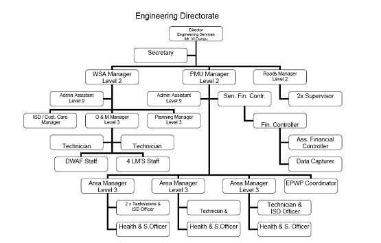
Organisational Structure
Engineering Directorate
| ||||||||||||||||||||||||||||||||||||||||||||||||||||||||||||||||||||||||||||||||||||||||||||||||||||||||||||||||||||||||||||||||||||||||||||||||||||||||||||||||||||||||||||||||||||